United States Map For Traveling [A Comprehensive Guide]

Traveling across the sprawling landscapes of the USA is a dream for many. A detailed United States Map For Traveling can be your best companion, showcasing every nook and cranny worth visiting. The importance of a reliable map when embarking on a journey in the United States cannot be overstated. The United States Tourist Map isn’t just any ordinary map; it’s tailored for travelers. Popular destinations gleam like stars, highlighting cities, national parks, and unique attractions that promise unforgettable experiences.
You were navigating the vast landscapes of a country as expansive as the USA can be daunting. The thrill of discovering a new city, the joy of an unplanned detour, or the serenity of a secluded spot can quickly turn sour if you find yourself lost, especially in unfamiliar territories. The solution? A comprehensive, traveler-friendly map. As you journey through this article, we promise to introduce you to maps that not only guide but enrich your American adventure.
The Essential Role of Maps in Modern Travel
Imagine setting foot in the vibrant streets of New Orleans during Mardi Gras, the crowd’s excitement palpable, colorful beads flying through the air. Or you’re atop a vantage point in the Rocky Mountains, the vast expanse of nature stretching before you. As a traveler, these experiences are unparalleled, moments that make the heart race and become etched in memory. Yet, there’s one companion that ensures these moments remain joyous and not marred by the anxiety of losing one’s way – a detailed United States Map For Traveling.
But just as every traveler is unique, so are their map preferences. Some might seek the bustling attractions and hidden gems of cities, while others yearn for the open road and the promise of a cross-country adventure. Some maps spotlight the radiant nightscapes of urban centers, and others guide you through the heartbeats of America’s vast countryside.

Population Density
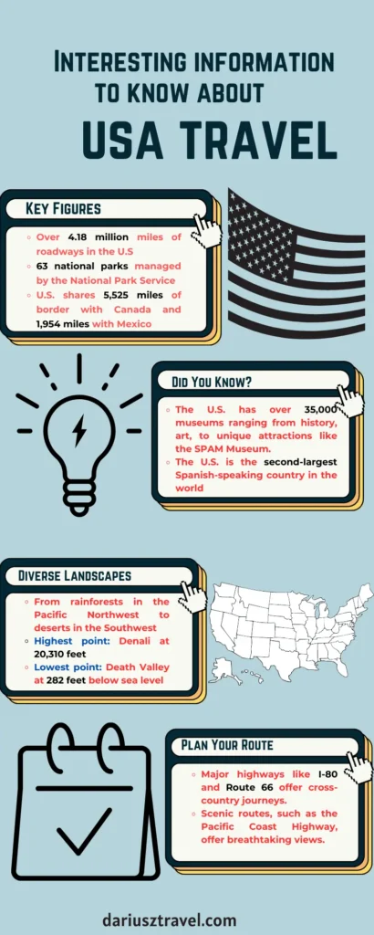
While the U.S. boasts vast cities like New York City, with a population density of over 27,000 people per square mile (as of 2020), there are expansive rural areas, particularly in states like Wyoming, where the density is as low as six people per square mile.
The Value of the USA Tourist Map
Stepping into the heart of Times Square, the screens aglow with a million colors, you feel the essence of New York City. Meanwhile, the calming whisper of waves on the shores of Malibu offers a contrasting yet equally mesmerizing, Californian experience. Such varied moments are from the soul of an American journey, and there’s a map designed to help you capture each of these experiences: the United States Map For Traveling. Unlike your everyday street maps, a tourist map is an experience.
Imagine having a personal guide with you, one who knows the ins and outs of every city, town, or countryside you venture into. This is what the USA Tourist Map strives to be. It’s not just about pointing north or south; it’s about directing you to the heart of every experience. Whether suggesting the best viewing spot for San Francisco’s Golden Gate Bridge, guiding you through the historical lanes of Boston’s Freedom Trail, or highlighting the best times to experience the cherry blossoms in Washington, D.C., this map is a traveler’s compass for unforgettable moments.
Moreover, the United States Map For Traveling masterfully accentuates popular tourist destinations. Picture it: you’re planning a visit to the Grand Canyon. On a regular map, it might just be another landmark, but on the tourist map, it becomes an experience waiting to be unfolded. From the best vantage points to nearby attractions and amenities, the map provides a 360-degree view of what to expect. Similarly, whether it’s the entertainment haven of Orlando’s theme parks or the musical streets of Nashville, each destination is adorned with detailed insights to make your journey smoother and more prosperous.
Dive into the United States Map For Traveling
Envision yourself strolling through the wine-soaked valleys of Napa, the air carrying whispers of stories from grapevine to barrel. Now, shift this panorama to the hustle and energy of Chicago’s Magnificent Mile, with its shopping allure and architectural wonders. These contrasting vibes, from tranquility to vivacity, define the diverse tapestry of America. One must dive deep into the United States Map For Traveling to truly unravel this intricate blend of regions, landmarks, and attractions.
Each region in the USA has its rhythm and narrative. The Pacific Northwest, with its lush forests and tech hubs, offers a blend of nature and innovation. In contrast, the Deep South sings a ballad of history, culture, and delectable cuisine. The United States Map For Traveling carefully demarcates these regions, ensuring travelers can tailor their journeys to their preferences. Be it the sun-kissed beaches of Southern California, the rugged terrains of the Rocky Mountains, or the rich heritage of New England, every region unfurls itself distinctly on the map.
Highway Length
The U.S. has a cumulative total of about 4.18 million miles of roadways, with approximately 47,000 miles belonging to the Interstate Highway System. This extensive network connects all major cities and regions, making road trips popular.
But it’s not just about regions; the magic is often in the details. Iconic landmarks such as Mount Rushmore, the Statue of Liberty, or the Hollywood Sign aren’t mere points on this map. Anecdotes, tips, and often accompany them, lesser-known spots nearby that might catch a traveler’s fancy. The map crafts a story, enabling travelers not just to visit but immerse themselves in each location.
The pragmatic benefits of the United States Map For Traveling are manifold. Planning routes become more than just connecting point A to B; it’s about designing an experience. The map aids in highlighting efficient routes and potential stops and even gives a heads-up about must-visit eateries or events along the way. Such meticulous planning ensures that time on the road becomes an integral part of the journey, filled with discoveries and delightful detours.
Map of North and South America with Countries
In the grand tapestry of travel, while individual threads of experience and discovery are crucial, the broader patterns often provide context, perspective, and depth to our journeys. As you set your sights on the USA, understanding its place within the more significant landscapes of North and South America can significantly enrich your adventures. Enter the Map of North and South America with Countries – a canvas that paints not just countries and boundaries but also stories, cultures, and the pulse of two vast continents.
For international travelers, diving into this broader map is imperative. The USA, while a mosaic of cultures and landscapes in its own right, is intricately connected to its neighboring countries. An understanding of these connections aids in crafting comprehensive travel plans. Maybe you’re Canadian venturing south, or perhaps you’re journeying up from Brazil. The United States Map For Traveling provides the logistical guidance you need.
But beyond logistics, the map is a treasure trove of cultural and geographic landmarks across the Americas. To the north, Canada beckons with its majestic Rockies, metropolitan cities like Toronto and Vancouver, and the rugged beauty of its Atlantic coastline. The unique French-Canadian culture of Quebec provides a taste of Europe within North America.
Moving southwards, Mexico awaits its rich tapestry of traditions, from the ancient Mayan ruins of Chichen Itza to the vibrant streets of Mexico City, resonating with music, dance, and art. Further down, Central America, with its string of seven countries, is a paradise of biodiversity. Rainforests, volcanoes, and pristine beaches define this belt, with each nation — be it Guatemala, Costa Rica, or Panama — offering a distinct flavor of culture and nature.
The exploration doesn’t end there. South America unfolds with its vastness, from the Amazon rainforests of Brazil to the Andean peaks. Experience the carnival spirit of Rio, the tango rhythms of Buenos Aires, the ancient Incan marvel of Machu Picchu in Peru, or the breathtaking landscapes of Patagonia that stretch across Chile and Argentina.
Cultural Hotspots
The U.S. has over 35,000 museums, from art and history to unique attractions like the SPAM Museum in Minnesota. Travel maps often spotlight major cultural institutions, but there’s a world of lesser-known gems to explore.
By engaging with the Map of North and South America with Countries, you’re not just plotting a journey but weaving a narrative that transcends borders. It allows you to understand the shared histories, the diverse cultures, and the interconnected ecosystems of the Americas. Whether you’re an avid adventurer, a history lover, or an interested tourist, this map provides that your view isn’t just comprehensive but scenic, delivering a holistic environment to your American adventures.
Map of Northern United States
Amidst the vast expanse of the United States, the northern regions emerge as a symphony of history, nature, and culture. It’s a land where metropolitan marvels coexist with natural wonders, where the whispers of the past are as loud as the bustling city streets. Delving into the Map of the Northern United States, travelers get a key to a region brimming with diverse experiences awaiting discovery.
The Northern USA is an eclectic blend of states, each boasting its unique flavor. From the cosmopolitan charisma of New York City, with its iconic skyline and cultural institutions, to the tranquil shores of the Great Lakes, this region has a captivating duality. One can stand amidst the bustling streets of Chicago, the Windy City, and in just a few hours, find solace in the serene landscapes of Michigan’s Upper Peninsula.
But it’s not just about the famous cities. The map will guide you to the lesser-known gems — the charming towns of New England, where fall foliage paints landscapes in shades of gold and red, or the Dakotas, where the rugged Badlands and the serene Black Hills offer a contrasting play of landscapes.
For visitors keen on delving deep into the region’s history, the Map of Northern United States is your time machine. Travel to Boston’s Freedom Trail to retrace the steps of American Revolutionaries or explore Philadelphia, where the Declaration of Independence was signed. Discover the industrial history of Pittsburgh, the steel city, and then experience the rich musical heritage of Motown in Detroit.
Elevation Extremes
The highest point in the U.S. is Denali in Alaska, standing tall at 20,310 feet. Conversely, the lowest point is in California’s Death Valley, at 282 feet below sea level. Detailed travel maps will mark these elevations, aiding in travel preparation, especially for hikers or mountaineers.
Essential Tips To Explore the Northern USA
Seasonal Splendors

While the summers bring warmth and vibrancy, with numerous festivals and outdoor activities, autumn in the northern states, especially in regions like Vermont and New Hampshire, is nothing short of magical. Plan accordingly if you want to witness the spectacle of fall foliage.
Diverse Cuisines

The Northern USA is a culinary paradise. From New York’s bagels and pizzas to Minnesota’s hotdish and Michigan’s pasties, ensure you indulge in the local flavors.
Nature Trails

Beyond the urban attractions, immerse yourself in the wilderness. Whether hiking in the Adirondacks of New York, fishing in Wisconsin’s lakes, or spotting wildlife in Ohio’s national parks, the northern states offer a plethora of nature activities.
Cultural Festivities

Keep an eye out for local events and festivals. Whether it’s the artsy vibes of Rhode Island’s film festivals, the traditional state fairs of Minnesota and Iowa, or cultural parades in cities like New York and Chicago, there’s always something happening.
Conclusion
Navigating the expansive terrains and diverse cultures of the United States and its neighboring continents requires more than just enthusiasm; it demands the right tools. Throughout this journey, we’ve unraveled the essence of various maps, from the detailed United States Map For Traveling, highlighting attractions and unique features, to the broader Map of North and South America with Countries, painting a holistic view of interconnected cultures and landmarks. We’ve also focused on the enchanting Northern United States, capturing its attractions and historical nuances.